
Climbing up to the Nam Xay Viewpoint in Vang Vieng in Laos.
Taking the iconic photo on the motorbike at the top of Nam Xay viewpoint was one of the highlights of my time in Laos.
The views were spectacular, and who doesn’t love a challenge in nature?
If you are planning your Laos itinerary and want more information about the famous Nam Xay viewpoint in Vang Vieng, then I am here to help you.
I knew that it wouldn’t be easy to grab the famous photo, but I didn’t know exactly what to expect in terms of the hike difficulty, the safety, and the crowds!
I have included all the information you will need as you plan your awesome Vang Vieng activity, to ensure that it goes smoothly
My personal experience was fun, so let’s make sure yours is!
We will start with how you can actually visit the famous nature beauty spot.

The iconic photo.
Disclosure: I sometimes use affiliate marketing. This will not cost you anything, but helps with my travel costs. I only recommend companies I use myself.
How can you visit the Nam Xay Viewpoint?
Most tourists who visit Vang Vieng are backpackers, therefore, renting a scooter or buggy is a popular choice.
It only costs between 80,000 - 200,000 LAK (£4- £8) per day to rent, depending on what you hire.
Another option is hire a tuk tuk driver or taxi, which will cost more, as the driver will have to wait for you.
This is still a pretty cheap option if you don’t feel confident driving yourself.
Many tours also include the famous viewpoints in group day tours, alongside the blue lagoons.

Exploring Vang Vieng.

So many scooters.

Refreshments in the car park.
Directions to Nam Xay Viewpoint from Vang Vieng Centre:
I found it to be very simple to find the viewpoint on my rented motorbike, as there are only a couple of main roads to follow, however, the actual state of the roads isn’t good, so you will find yourself moving across the road to avoid giant potholes etc.
Here is a step by step guide:
If you’re in the town centre, head towards Route 13 (the main highway that runs through Vang Vieng).
Travel about 7 km south on Route 13.
You'll pass Blue Lagoon 1 Road on your right (ignore this road).
Continue straight until you see signs for Nam Xay Viewpoint and Pha Ngern Viewpoint.
Look for a wooden signboard pointing toward Nam Xay Viewpoint.
Turn right onto the dirt road (unpaved and dusty).
Drive about 500 metres along this dirt path.
You’ll reach a small parking area where you can park your motorbike or bicycle.
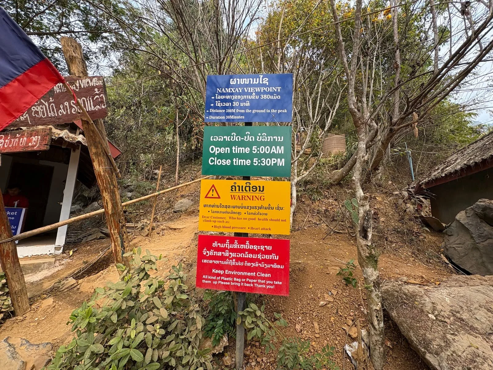
Nam Xay Viewpoint entrance fees and opening times.
Opening times:
5.00am until 5.30pm.
Entrance fees:
20,000 LAK (£1).
Some important information.
How difficult is the hike?
I am a fit and active person and I would rate the hike as an 8/10 difficulty, which factors in the steep gradient, high temperatures, high humidity, and lack of safety guides.
I did see some elderly tourists at the top, so it is an accessible hike, but some visitors may have to take it slowly.
If you have plenty of time then you can afford to take it steady.
The views are just as good for someone who takes an hour to reach the top as someone who takes 20 minutes!

Here we go.
In total, it is around 400m in elevation to the peak of the viewpoint.
On average in the busier months, you are probably looking at 45 minutes to reach the top, as crowds do gather in certain parts of the route, which creates bottlenecks.

Some sketchy sections.
As you can see in the photos, there are some very steep sections which require some upper body strength to pull yourself up to scramble over rocks.
The path also consists of some loose gravel and sharp rocks, making it easy to lose your footing.

The hike is tricky in many places.
This photo below of the ladders is the most help you will get at any point of the hike.
Other than this, it is trees, ropes or bamboo poles in some places, or rocks which will act as your hand aids.

Some places have more assistance.
The marker points don’t make it any easier!
There are marker points every 100 metres on the hike, and they can be useful for pacing yourself, and motivating you.
I didn’t really find that they helped me, as the most difficult points of the hike are towards the top anyway.
The hike is steep, so reaching a marker can give you a good excuse to stop, rest, and hydrate though.

The first marker point.

The last marker.
What to expect at the top.
As with many attractions in South East Asia, I was expecting to see some sellers with refreshments and souvenirs at the top, however, it must be too dangerous and hot for the locals, as there was no sign of any of them up there.
You will find two or three benches to sit and try to cool down, and get your breath back.
A wooden hut is also present to add a little reassurance for tourists, but this was filled with queuing visitors when I was there.
Other than that, you will find the two famous motorbikes, which the locals have somehow managed to transport up the 400 metres high rock.
I found this to be remarkable when you see the trails which you have to use to ascend.

Finally my turn for the photo.
The iconic photo opportunities.
Before visiting Laos, the famous motorbikes on top of Nam Xay will capture many backpackers’ attention!
There are two motorbikes, one facing east, and one west, both offering different backdrops.
Both are popular with visitors, as sitting on the bikes makes it look like you’re riding above the clouds.
The Laos flags are another nice prop which adds to the adventurous photo.

The east side motorbike didn’t have queues.

An awesome backdrop.
Epic panoramic views.
The full beauty of Laos reveals itself from all angles as you take a moment to immerse in the breathtaking surroundings at the summit.
I really enjoyed the amount of lush greenery that fills the valley.
There are unique aesthetics as the limestone cliffs are filled with lush nature!
Vast rice fields stretched as far into the distance as I could see.

Surreal views.
Expect some queuing.
When reaching the top you should be prepared to queue, as you would expect with such an iconic photo opportunity!
I only had to queue for the most popular motorbike, which is the westside one, as it offers the dramatic valley backdrop.
This is the one you will have seen online before visiting!
In total, I had to queue for around 20 minutes, however, I didn’t mind this, as it gave my body the chance to cool down from the difficult hike up there.
If you are in a hurry, then it may be frustrating for you, as plenty of visitors take their time, capturing multiple angles and group selfies etc.
An early morning visit is probably the best option to avoid this malarkey.
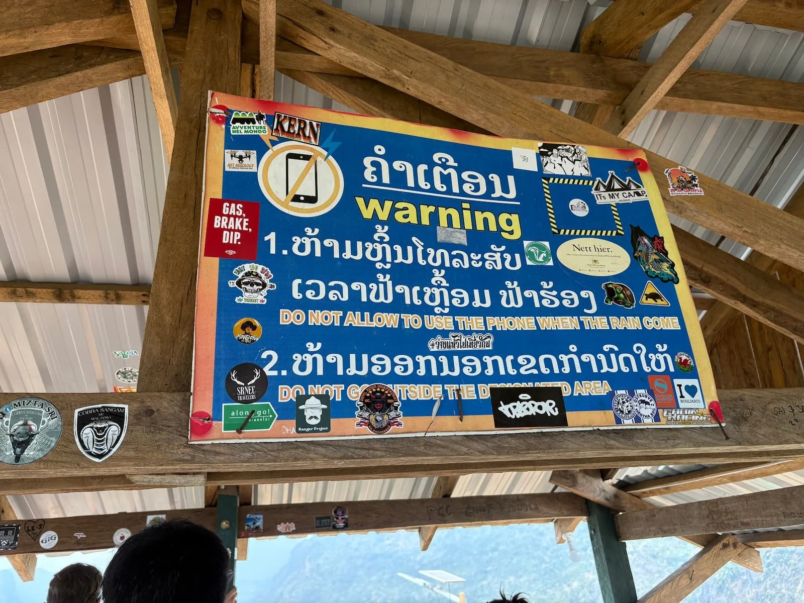
This is far as it goes in terms of safety.
Is the hike safe?
My personal experiences in Laos were that there isn’t the same level of safety as in its neighbouring, more visited countries, however, the hike to Nam Xay Viewpoint is very popular and generally safe.
The amount of tourist footfall has created a somewhat of a trail up to the top, and the locals have added some rails (although very few), ropes, and other things which can be used as aids during the steeper sections of the hike.
Some safety considerations for you to think about:
Uneven terrain - Although the trail is relatively short, it is very steep and isn’t smooth. It will require you to do some climbing, slow walking, and even sitting on the way down.
Slippery after rain - If visiting during the rainy season you can expect heavy downpours on some days, which makes the trail much more tricky.
Exposed areas when you reach the summit – The viewpoint sits on jagged rocks with steep drops, so be extra careful when taking photos, especially near the motorbike and edges. This means that wind and rain can catch you off guard.
Limited light after sunset - Ideally you want to be planning your hike in the day time, as the trail isn’t lit up at all after sunset. Although the site does shut at 5.30pm, tourists have been known to go and tackle the climb at night.
Very few handrails or guardrails - There are a few steps, and bits of rope, but most of the trail lacks safety barriers, so three points of contact is essential in some spots.
The best time to complete the hike.
Visiting Vang Vieng in the dry season between the months of November and April will make your experience at Nam Xay more enjoyable, and safer.
In the rainy season the trails can be very slippery, and the views can be ruined by mist, fog, and rain.
I found February to be a good time to visit, as the heat wasn’t too uncomfortable, and it was safe, but not too busy.

There aren’t many safety precautions.
Important tips and considerations before your visit.
If you are heading to Vang Vieng soon, then here are some things to consider, and tips to make sure your trip to Nam Xay viewpoint is safe and enjoyable:
Wear closed trainers with good grip.
It can get very slippery and dusty on the trail, especially after rainfall. It is doable with flip flops, but your hike won’t go as smoothly.
Carry water up there.
This hike is short, but very strenuous, so you will get very hot and sweaty. I recommend taking two waters, one for each way. You can buy water and other refreshments at the start of the hike.
Be the early bird.
An early morning visit results in fewer crowds, cooler temperatures, and less intense sunshine, so if possible plan around this.
Don’t litter.
In the South East Asian countries, the locals are very big on keeping the environment clean, so please respect this. There are rubbish bags at the top for you to dispose of your plastic bottles etc.
Keep your hands free.
The difficult sections of this hike will require both of your hands to grab hold of trees, rocks, and some of the rope assistance, so carry a small bag for your items. This will keep you safe.
Consider your true fitness levels.
This is an intense and steep climb, so if you are not very mobile, or not very active, then maybe consider whether you can handle it in the heat.
There were some elderly climbers when I visited, however, there were also younger tourists really struggling.
If you have plenty of spare time, you can take it slowly!
Disclosure: I sometimes use affiliate marketing. This will not cost you anything, but helps with my travel costs. I only recommend companies I use myself.